A friend sends you a video clip. A man stands in the Saudi desert beside a mountain with a black, burnt-looking top. He points to a fenced-off area, at a large split rock, at some rock carvings that look like cattle. He says, with total confidence, this is the Mount Sinai. The church, he insists, has been wrong for 1600 years.
So where is Mount Sinai? The honest answer: nobody really knows for certain. But that doesn’t mean all options are wrong. Or equally strong. Scripture gives us a set of clues, and those clues work like a filter. Some candidates pass through most of them. Others fail badly. And on a few points, the evidence simply runs out, and the right thing to do is say so.
This post sets out what the Bible requires of the mountain. It weighs the three leading candidates against those requirements and scores them side by side. It also explains why the uncertainty is no threat to faith—and why God may have left the location unmarked on purpose.
Why this question is suddenly everywhere
The question is old, but the noise around it is new. Four things have converged:
- Documentaries. Several well-made films argue for a mountain in north-west Saudi Arabia, reaching millions who’ve never read an archaeological report.
- Saudi tourism. The Tabuk region, closed to outsiders for decades, is now open to visitors. Places that were once rumours are now photographs.
- The dispute over St Catherine’s Monastery. A legal row over the ancient monastery at the foot of the traditional mountain has put that site back in the headlines.
- Social media. Claims from the 1980s by amateur explorer Ron Wyatt circulate endlessly, stripped of the replies made at the time.
Most of such material is advocacy, produced by people who have axes to grind. They already have a conclusion to sell. What is missing is a plain scorecard.
What Scripture actually requires
Before comparing mountains, we need to know what we’re looking for. The Bible never gives coordinates. But it does give a surprising amount of detail, scattered across several books.
FIRST, A SMALL PUZZLE: SINAI OR HOREB?
The Bible uses two names for the same mountain. Exodus mostly says Sinai; Deuteronomy mostly says Horeb. Exodus 3:1 calls it Horeb, and the same mountain is later called Sinai in Exodus 19.
The simplest explanation, and the one held by most careful readers: Horeb refers to the wider mountain range or region, and Sinai to the particular peak within it—rather like saying “the Alps” and then “the Matterhorn”. Nothing in the argument below depends on this, but it saves confusion when we read the texts.
From the relevant passages we can draw seven tests. A serious candidate should pass most of them.
| THE TEST | THE TEXT BEHIND IT | WHAT IT MEANS IN PRACTICE |
|---|---|---|
| On the recorded route from Egypt | Exodus 12–19; Numbers 33 | The mountain must sit on a believable line of march from the Nile Delta, with the recorded stopping places falling in sensible order. |
| In or near Midian | Exodus 3:1 | Moses was shepherding for Jethro, priest of Midian, when he reached the mountain. So it lay within reach of Midianite grazing land. |
| A plain at the base | Exodus 19:2 | The people “camped before the mountain”. That needs open flat ground next to the peak, not a narrow gorge. |
| A clear boundary | Exodus 19:12 | The people were forbidden to touch its edge. That implies a definite foot—a mass you can mark a line around. |
| Visible and audible to all | Exodus 19:11, 16–20 | The whole camp saw the smoke and heard the trumpet, so the peak must be visible from the camping ground. |
| Water and pasture | Exodus 3:1; 17:6 | Flocks grazed there, and a very large group stayed nearly a year. So there must be water in the area. |
| 11 days from Kadesh-barnea | Deuteronomy 1:2 | Moses gives a distance in travel days: 11 days from Horeb to Kadesh-barnea. This is a real constraint, and it’s often ignored. |
Two further points shape the search, and both are often misused.
“MOUNT SINAI IN ARABIA”—WHAT GALATIANS 4:25 DOES AND DOES NOT PROVE
Paul writes Hagar is Mount Sinai in Arabia (Galatians 4:25). This is the strongest verse used by supporters of a Saudi location, and it deserves a fair reading.
What it establishes: the mountain lay in a region the 1st-century world called Arabia. That’s real evidence and shouldn’t be waved away.
What it doesn’t establish: the mountain lay east of the Gulf of Aqaba. In Paul’s day “Arabia” meant the Nabataean kingdom, and from AD 106 the Roman province of that name. Both took in large parts of the Sinai Peninsula.
What Paul is doing: his subject isn’t geography but two covenants. The location is a passing detail, which is why he adds no description.
Verdict: Galatians 4:25 is consistent with a peninsula site and consistent with an Arabian site. It narrows nothing on its own.
THE PROBLEM OF THE MISSING EVIDENCE
Archaeologist Israel Finkelstein and others have surveyed the Sinai Peninsula closely and found no remains from the Exodus period. Some use this to argue the Exodus never really happened.
Egyptologist Kenneth Kitchen has given the standard reply, and it’s strong: people living in tents and moving on leave almost nothing behind—no stone buildings, no rubbish tips, no cemeteries of the kind that mark settled life. A group passing through once, however large, is close to invisible.
This cuts both ways. Absence of finds isn’t proof that nothing happened—but no candidate site can claim clinching archaeological support. That does not exist. Be cautious of anyone, on any side, who says the digging has settled it.
Candidate 1: Jebel Musa, southern Sinai Peninsula
Jebel Musa means “the mountain of Moses”. It rises to about 2,285 metres in the granite mountains of the southern Sinai Peninsula, with St Catherine’s Monastery at its northern foot.
This is the traditional site. Christian hermits settled the region by the 4th century, and pilgrim Egeria, a Spanish woman who travelled east in the early 380s, left a detailed account of climbing it. Emperor Justinian built a fortified monastery in the 6th century. From then until modern times, this was simply where Christians understood Mount Sinai to be.
The case in its favour
- Long tradition. 16 centuries of unbroken identification isn’t nothing. Local memory of places often survives long before anyone writes it down.
- The plain of Er-Raha. A broad open plain lies at the mountain’s foot, commonly estimated at around 4 square kilometres, with the peak clearly in view. It fits Tests 3 and 5 well.
- The distance works. From Jebel Musa to Kadesh-barnea is roughly 240 kilometres. Over 11 days that’s about 22 kilometres a day—a normal pace for a travelling party in that terrain. Test 7 passes comfortably.
- Water. The high granite massif holds springs and wells that still support settlement today.
The case against
- The tradition may have begun with the monks. This is the strongest objection. We can trace the identification to 4th-century monastic settlement, but no further. If the monks chose the peak, we have a very old opinion, not an inherited memory.
- Nothing has been found. No remains from the Exodus period have been recovered anywhere in the peninsula, including here.
- Egyptian territory. Egypt ran turquoise and copper mines in the western Sinai, with garrisons. Whether a large group could pass unnoticed is a fair question, though the southern massif lies away from the mining zones.
- Is it in Midian? Midian is normally located east of the Gulf of Aqaba, which puts Jebel Musa outside it. Supporters answer that Midianites were herders and traders who ranged widely, and that Exodus 3:1 says Moses led the flock to the far side of the wilderness—language that suggests a journey away from his base, not a stroll behind the tent.
Candidate 2: Jabal al-Lawz and Jabal Maqla, north-west Saudi Arabia
This is the location behind almost every viral video, and it’s also the one most often described inaccurately. Before weighing it, a point of basic clarity is needed.
TWO MOUNTAINS, ONE NAME—A DISTINCTION MOST POPULAR SOURCES BLUR
Jabal al-Lawz: the higher northern peak, about 2,580 metres, and the name used in nearly all headlines and video titles.
Jabal Maqla: a lower peak in the same range to the south, about 2,326 metres. This is the mountain with the dark, blackened summit shown in the documentaries. This is the peak actually being proposed.
When a video says “Jabal al-Lawz”, it’s usually showing you Jabal Maqla. Keeping the two apart is the first step to assessing the claim rather than the marketing.
The modern case begins with Ron Wyatt, who visited in 1984, and was taken up by Robert Cornuke and Larry Williams in 1988. It has since been argued at greater length by Glen Fritz, a geographer who concentrates on the sea crossing, and by Joel Richardson, whose film and book reached a mass audience.
The case in its favour
- It’s in Midian. This is the real strength of the proposal and should be granted plainly. Midian is normally placed in exactly this region, so Test 2 passes more naturally here than anywhere else.
- A large plain. A broad plain lies to the east of Jabal Maqla, wider than Er-Raha. Tests 3 and 5 pass.
- Local memory. There are reports of local Bedouin traditions attaching significance to the mountain, and of a nearby site associated with Jethro.
- It fits Galatians 4:25 like a glove. For many readers this is the heart of the argument, even though the verse allows both readings.
The case against
- No excavation report exists. This is decisive and rarely stated clearly. No controlled excavation of the site has been published in a peer-reviewed journal by anyone, for or against. What is on offer is photography and interpretation, and a claim this big cannot rest on that.
- The blackened peak has an ordinary explanation. The dark cap isn’t scorching. It is a layer of dark igneous rock. Break a piece open and it’s dark inside as well as out—which burning wouldn’t produce. The same dark rock appears on other peaks in the range that nobody proposes as Mount Sinai.
- The split rock is a common formation. A large split boulder is offered as the rock struck at Horeb. Frost, heat expansion and weathering along natural joints produce such rocks routinely, across this region and far beyond.
- The carvings are probably much later. Gordon Franz, who has examined the material closely, argues the cattle-like carvings near the so-called altar are Nabataean, roughly a thousand years after any Exodus date, and that similar carvings are scattered across north-west Arabia. Cattle images in the desert are common; they’re not a golden calf.
- The fence proves nothing. Videos show a fenced-off area and present it as a cover-up. But fencing is what heritage authorities do at known archaeological sites, to keep out looters and vehicles. The site does have ancient remains, mostly from much later periods. A fence tells you a place is protected. It doesn’t tell you which place it is.
- The distance doesn’t work. From this mountain to Kadesh-barnea is about 400 to 480 kilometres, going the long way round the top of the Gulf of Aqaba. Deuteronomy 1:2 puts that journey at 11 days. That would mean covering roughly 40 kilometres every single day, without a rest. Supporters answer the 11 days may describe a fast messenger rather than ordinary travellers. That’s possible. But the simple reading of the verse fits a mountain in the peninsula far better.
- It needs a second big claim. To reach this mountain, Israel must have crossed the sea at the Gulf of Aqaba rather than further west. That gulf is deep, and the sea floor drops away steeply close to the shore. Glen Fritz argues the case seriously and deserves a hearing. But notice what has happened: before you can accept the mountain, you must first accept a new crossing point. That is a second large claim, and it has to be proved, not assumed.
A word about the Ron Wyatt material
Much of what circulates online—chariot wheels on the seabed, a coral-encrusted axle, gold-covered wheels—traces back to Ron Wyatt. None of these objects has ever been produced for independent examination, and no verified artefact from any of these claims sits in any museum or laboratory.
We say this without malice; many sincere believers have been moved by these stories. But a faith resting on objects nobody can check is resting on sand, and when they fail, faith is shaken with them. Better to learn early that the wheels cannot be examined than to hear it later from a hostile critic.
Candidate 3: Har Karkom, in the Negev
Har Karkom is a low plateau-mountain of about 847 metres in the Negev desert of southern Israel, and the life’s work of Emmanuel Anati, an Italian archaeologist who has surveyed and excavated there since 1980.
This is the one candidate where the archaeology is genuinely impressive.
The case in its favour
- Real worship sites. Anati has documented altars, standing stones and open-air shrines in large numbers—physical evidence of religious activity, not merely a suggestive skyline.
- Extensive rock art. Well over 1000 rock-art sites cluster around the mountain, including a carved panel some have compared to tablets divided into sections.
- A camping area. Traces of encampment lie at the foot of the mountain.
The case against
- The dates don’t fit. The great period of activity falls in the 3rd and 4th millennia BC, long before any proposed Exodus date, whether about 1446 BC or about 1250 BC. In the period that concerns us, the site appears largely abandoned.
- The proposed solution is costly. Anati’s answer is to move the Exodus back to fit the archaeology. That detaches it from the Egyptian setting the text describes and from the chronology of Kings and Judges—solving one problem by creating larger ones.
- It isn’t in Midian. The Negev is a long way from Midianite territory.
Har Karkom is best understood as a genuinely important ancient sacred mountain—but a sacred mountain of the wrong era.
The also-rans, briefly
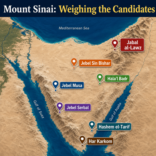
At least a dozen other peaks have been proposed. Four are worth knowing about, because they show the range of the debate.
| Site and location | Argued by | Its attraction | Its difficulty |
|---|---|---|---|
| Jebel Sin Bishar Western Sinai Peninsula, near Suez | Menashe Har-El, Israeli geographer | Close to Egypt, and fits the early stops on the recorded route. | Only about 618 metres, and very close to Egyptian-held territory. Hard to square with a mountain of terror and isolation. |
| Hala’l Badr North-west Arabia | Colin Humphreys, Cambridge physicist, among others | An actual volcano. If the fire, smoke and shaking of Exodus 19 describe an eruption, this supplies one. | The text adds a trumpet blast and an audible voice, which no volcano supplies—and an eruption would have destroyed the camp, not summoned it. |
| Jebel Serbal Southern Sinai Peninsula, near Wadi Feiran | Favoured by some of the earliest hermits in the region | A striking peak with early Christian settlement nearby; possibly an older tradition than Jebel Musa. | No plain at its base large enough for the camp. Test 3 fails. |
| Hashem el-Tarif North-eastern Sinai Peninsula | Promoted mainly through documentary work | Isolated, with flat ground nearby, and keeps the route inside the peninsula. | No tradition of any kind attaches to it, and no excavation supports it. |
The scorecard
Here are the three leading candidates measured against the seven biblical tests. The purpose is not to declare a winner by counting ticks, but to show clearly where each proposal is strong and where it strains.
| Biblical test | Jebel Musa (Egypt) | Jabal Maqla (Saudi Arabia) | Har Karkom (Israel) |
|---|---|---|---|
| On the route from Egypt | Pass: fits the itinerary as written | Partial: needs the sea crossing moved to Aqaba | Partial: possible, but the stops fit poorly |
| In or near Midian | Weak: outside Midian as usually placed | Pass: its strongest point | Fail: the Negev is far from Midian |
| Plain at the base | Pass: the plain of Er-Raha | Pass: a broad plain to the east | Pass: encampment area identified |
| Clear boundary at the foot | Pass: sharply defined granite mass | Pass: defined peak | Weak: a plateau rather than a single peak |
| Visible and audible to all | Pass | Pass | Pass |
| Water and pasture | Pass: springs still in use | Pass: wells in the region | Weak: very arid |
| 11 days to Kadesh-barnea | Pass: about 240 km, a normal pace | Fail: some 400–480 km, about 40 km a day | Fail: far too close to fit eleven days |
| Archaeology from the Exodus period | None found | None published | Rich, but from the wrong millennium |
| Ancient tradition | Strong from the fourth century AD; earlier chain unproven | Local reports only; nothing in ancient writing | None |
How to read this table: “Pass” means the candidate meets the test without special pleading. “Partial” means it can be made to work, but only with an extra assumption. “Weak” means it fits poorly. “Fail” means the test tells against it. No candidate scores a clean sweep—which is the honest state of the question.
What we can and cannot say
Pulling the threads together:
Where the evidence leaves us
We can say: Jebel Musa remains the best-supported candidate overall. It fits the itinerary, has a suitable plain, satisfies Deuteronomy 1:2, and carries 16 centuries of tradition.
We can say: the Midian objection to Jebel Musa is real and shouldn’t be brushed aside. It’s the one point where the Arabian proposal is genuinely stronger.
We can say: the Jabal Maqla case, as presented, rests on visual resemblance rather than excavation. The blackened rock, the split rock and the carvings all have ordinary explanations.
We can say: Har Karkom is an important ancient sacred site, but from the wrong period.
We cannot say: that any location is proven. Not one.
We cannot say: that the traditional site rests on evidence older than the fourth century AD.
We cannot say: that archaeology has confirmed the events at the mountain, or refuted them. It has done neither.
Pause on how odd this is. Israel knew where Mount Sinai was; Elijah walked there (1 Kings 19:8). Yet no pilgrimage was ever commanded, no feast pointed back to the spot, no shrine was built. In a culture that remembered the burial places of its patriarchs in detail, the most important mountain in its history simply drops out of the record.
That silence looks deliberate.
Why not knowing isn’t a problem
There’s a pattern in Scripture that explains the missing mountain better than any theory of lost records.
- Moses’ grave was hidden. God buried him, and Deuteronomy 34:6 says no one knows the place of his burial to this day. The greatest prophet of the old covenant has no tomb to visit.
- The bronze serpent was destroyed. The object God had told Moses to make, which saved lives in the wilderness, was smashed by King Hezekiah because Israel had begun burning incense to it (2 Kings 18:4). A God-given relic became an idol within a few centuries.
- The ark disappears without comment. The most sacred object in Israel’s worship vanishes from the narrative, and the prophets never call for a search party. Jeremiah says the day is coming when it will not even be missed (Jeremiah 3:16).
The pattern is consistent. God doesn’t preserve holy places and objects for us, because we’re very good at worshipping them. Had the mountain been marked, there would be a shrine on it, a trade in stones from it, and arguments over who controls the summit. We know this because we’ve done it with less.
The New Testament says it directly. Hebrews contrasts the mountain that could be touched, burning with fire and gloom, with what believers have come to: the heavenly Jerusalem, and Jesus the mediator of a new covenant (Hebrews 12:18–24). The physical mountain was the shadow. We’re not called to find it; we’re told we’ve arrived somewhere better. Infinitely better.
Paul does the same in the very verse used to argue for Arabia. He mentions Sinai’s location only to leave it behind, because his interest is in the Jerusalem above, which is free, and which is our mother (Galatians 4:26).
So if an expedition announced tomorrow the case was settled, sure it would be fascinating. But it would change nothing. If the mountain is never identified, the covenant given on it, and the One who fulfilled it, stand exactly as they were.
God buried Moses so no one could build a shrine over him. It would be entirely like God to have done the same with the mountain, too, don’t you think?
Tough Questions, Honest Answers
What about the chariot wheels found in the Red Sea?
No verified chariot wheel from the Exodus has ever been recovered from the Gulf of Aqaba or anywhere else. The photographs that circulate show coral formations and objects that have never been brought up, examined by specialists, or placed in any collection where they can be inspected. Ron Wyatt, the source of most of these claims, described gold-covered wheels and an axle, but nothing was ever produced. Believers should be the last people to defend a claim that cannot be checked. Our confidence rests on the testimony of Scripture, not on an object at the bottom of a gulf that nobody has ever held.
Does the date of the Exodus change which mountain we should be looking for?
It changes the archaeology we would expect to find, though not the geography. On the earlier date, around 1446 BC, we are searching in the Late Bronze Age; on the later date, around 1250 BC, we are near the end of it. Either way, Har Karkom is ruled out, since its main activity is two thousand years earlier. The choice between the two dates matters greatly for questions like the identity of Pharaoh and the fall of Jericho, but it does not favour Jebel Musa over Jabal Maqla or the reverse. Both remain live options on either chronology.
Was Mount Sinai a volcano? Would that explain the fire and the smoke?
Exodus 19 describes smoke rising like the smoke of a kiln and the whole mountain trembling, and that has reminded many readers of an eruption. Colin Humphreys has argued along these lines for a volcanic peak in Arabia. But the description does not fit. There is a trumpet blast growing louder, and an audible voice speaking words the people understood, and a mountain the people were told not to touch rather than to flee. An erupting volcano would have destroyed the camp at its base, not summoned it. More importantly, the passage does not read as an attempt to describe a natural event. It presents God making Himself present in fire, as He does at the burning bush and in the pillar of fire.
Should Christians visit the site if it is ever identified?
Visiting is not sinful. Seeing the land of the Bible can deepen a reader’s understanding of the text in ways that maps cannot. The danger lies elsewhere. Once a place is treated as holy in itself, people begin to expect that being there brings them nearer to God than being at home does, and that is precisely the mistake Jesus corrected at the well in Samaria: the hour has come when true worshippers worship the Father in spirit and truth, not on this mountain or in Jerusalem (John 4:21–24). Go as a traveller and a student. Do not go as a pilgrim seeking access to God that Scripture says you already have through Christ.
If God wanted us to trust the Bible, why did He not preserve the location?
The assumption behind the question is that physical proof produces faith. Scripture repeatedly suggests otherwise. The generation that stood at the mountain, saw the fire, heard the voice and ate bread from heaven made a golden calf within weeks. Proof of the most direct kind did not secure their loyalty for a month. What God has preserved is His word, and the promise attached to it, and the Spirit who makes it convincing. The abolition of the shrine is a mercy, not an oversight: it prevents us from mistaking a place for a Person.
How is Mount Sinai connected to Mount Zion in the New Testament?
The two mountains function as a pair. Sinai is where the law was given in fire and terror, with a boundary the people could not cross on pain of death. Zion, in Hebrews 12, stands for what believers have come to in Christ: a city, a festal gathering, a mediator, and blood that speaks a better word than the blood of Abel. Paul uses the same contrast in Galatians 4, setting Sinai and the present Jerusalem against the Jerusalem above. The point is not that the law was bad, but that its terrors have been absorbed by Christ. The boundary at the foot of the mountain has been opened, and it was opened from the inside.
A friend is convinced by a documentary. What should I say?
Start by granting what is true, because a great deal of it is. The Arabian location does sit in Midian, and that is a real strength worth saying out loud. Then ask one quiet question: has any of this been excavated and published? That question does the work, because the answer is no, and it moves the conversation from footage to evidence. From there you can walk through the ordinary explanations for the blackened rock and the split rock without appearing to defend a rival theory. And finish where it matters, by pointing out that no article of the faith rises or falls on the answer—which frees both of you to be genuinely curious rather than defensive.
Related Reads
- Mount Sinai in Arabia: What Paul Meant in Galatians 4:25
- Examining Ron Wyatt’s Mount Sinai Claims
- Was Mount Sinai a Volcano?
- Is the Bible Historically Reliable? Here’s What the Evidence Shows
- BC 1446 or 1250: When Did the Exodus Really Happen?
- Hezekiah and Assyria: 7 Archaeological Discoveries Confirm Scripture
- What Do the Dead Sea Scrolls Prove? The Case for Bible Reliability