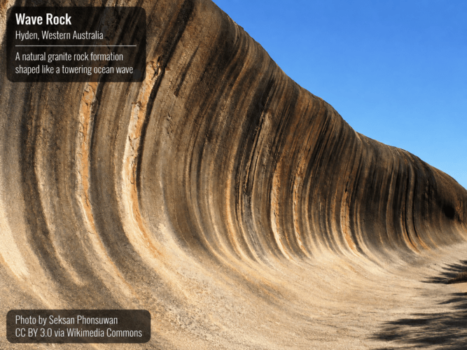
Drive 300 kilometres east from Perth in Western Australia and the wheat farms give way to dry scrub, red soil and salt lakes. There, beside the small town of Hyden, stands one of the strangest sights on earth. A wall of granite 15 metres high and over a 100 metres long curls forward at the top, exactly like an ocean wave about to break. Stripes of grey, orange, red and black run down its face like streaming water. It’s called Wave Rock.
The strange part is where it stands. The sea is hundreds of kilometres away, the land is flat, hot and dry, and most rivers on the map hold no water. Nothing happening there today could carve a 15-metre wave out of solid stone. So what did?
The tourist signs say water slowly rotted the rock underground over tens of millions of years. That’s a serious answer from serious scientists. But geologists have recently begun arguing in leading journals about whether it works at all. This article looks at the rock, at that argument, and at a possibility the signs never mention: that Wave Rock is a leftover from the global flood.
First, meet the rock
| FEATURE | DETAIL |
|---|---|
| Where | The north face of Hyden Rock, about 300 km east of Perth |
| Size | Roughly 15 metres high, 110 metres long |
| Rock | Monzogranite, a coarse granite of the Yilgarn Craton |
| Usual age given | The granite: about 2.7 billion years. The wave shape: from about 100 million years ago onwards |
| Aboriginal name | Katter Kich, in the language of the Ballardong people of the Noongar nation |
| What lies north | A wide, sand-filled ancient river channel (a palaeovalley), part of the Camm River system |
Two words will keep coming up, so let’s see what they mean.
- Inselberg: German for ‘island mountain’. A lone hill of hard rock standing above a wide flat plain, like an island in a calm sea. Uluru is the famous example.
- Flared slope: the name for the wave shape itself. A curved, overhanging cliff, scooped inwards at the bottom.
The usual explanation: rotting from below
The standard account comes from the Australian geomorphologist Charles Rowland Twidale, who wrote on Wave Rock in 1968 and defended his view for over 50 years. It runs like this.
Long ago the granite dome was buried under soil. Rainwater gathered at its foot, where the ground stayed damp longest. Damp rock rots. Over vast ages the groundwater ate into the granite there, turning stone into crumbly clay and hollowing out a curve. Much later, erosion stripped the soil and the rotted rock away together, and out came a ready-made overhang. On this view the wave was shaped underground, in the dark, and only uncovered later.
It’s a clever idea. But notice what it needs: tens of millions of years of quiet rotting, then a stripping event, then almost no erosion ever since, so that a thin overhang survives in the open air.
Why that explanation is now in trouble
In April 2021, Solomon Buckman, Rowena Morris and Robert Bourman of the University of Wollongong published a paper in Nature Communications. They began by admitting the processes behind flared slopes are, in their own word, “enigmatic”—meaning nobody really knows. That’s a striking confession about a landform explained so confidently on tourist signs.
They then offered something completely different. Bushfire, not groundwater, may do most of the shaping. Intense heat makes the outer skin of rock flake off in thin plates, a process called spalling. Because fire burns at ground level, the flaking happens around the base of a rock, eating sideways and leaving an overhang. Fresh flaking was found everywhere after the Australian fires of 2019 and 2020.
Twidale didn’t accept this quietly. In 2023 he co-authored a reply in Earth-Science Reviews under a title that tells you everything: “Flared slopes: The work of water or fire?” In 2025 a modelling study in the Journal of Geophysical Research concluded repeated fires can mimic these shapes.
Why the Word ‘Mimic’ Matters
If two completely different processes can produce the same shape, the shape alone cannot tell you which one made it—still less how long it took. The millions of years attached to Wave Rock aren’t read off the rock. They’re brought to it before anyone starts looking.
Clue 1: The wave faces one direction
Here’s the first problem for the rotting model, and it’s simple.
- Groundwater has no direction. Damp soil surrounds a buried dome on every side, so soil moisture should leave an even skirt of flaring right round the base.
- Flowing water does. A river presses against one bank and undercuts it. It never touches the bank behind.
- The wave sits on one face. It occupies the northern side—and running immediately north of it, marked on the official geological map, is a wide old watercourse nearly a kilometre across.
Tas Walker, an Australian geologist who writes on biblical geology, reconstructs it plainly. Hyden Rock stood as a leftover stump while a great volume of water swept past in a broad channel. As the land around kept lowering, the current kept cutting into its base, leaving a long curving undercut on the side facing the flow.
One objection deserves an answer. Flared slopes are sometimes found on several sides of a rock, and at more than one height. Does that sink the water explanation? No—it strengthens it. Draining water doesn’t stay at one level. It falls, and curves at several heights are what a falling water surface leaves, each pause cutting its own notch. Steady underground rotting should carve one line, not a staircase.
Clue two: the valleys are far too big for their water
Step back and look at the country around the rock. The valleys are enormous; the water in them isn’t. Using public elevation data, Walker measured a valley about 30 kilometres west of Hyden. The visible sandy channel is around three kilometres wide, yet it sits inside a valley some 17 kilometres wide and 60 metres deep, where water hardly ever flows now. Geologists call this an underfit stream—a river far too small for its valley. Geoscience Australia has mapped a whole network of these dead valleys across arid Western Australia, South Australia and the Northern Territory.
Those channels have broken into disconnected chains of salt lakes. Drainage here didn’t slowly shrink. It stopped.
Clue three: the flat plain and the missing kilometres
An inselberg cannot exist without a plain, so before explaining Wave Rock we should explain the flatness around it. What makes a landscape flat? Ordinary rivers do the opposite. Given long ages, running water cuts down and produces a branching network of valleys and ridges, like the veins on a leaf. Slow erosion carves; it does not smooth. What does make a broad flat surface is a sheet of moving water spread across a whole region, shaving the land as it passes. Creation geologist Michael Oard has collected such cut-flat surfaces, topped with stumps of hard rock, from every continent. His argument is simple: this is the signature of a huge body of water in retreat.
And if kilometres of rock were stripped off Western Australia, it ought to have escaped somewhere. It did. West of the Yilgarn lies the Perth Basin, where cross-sections show about 12 kilometres of layered rock on the same ancient basement. It survived because that block dropped some 15 kilometres along a giant crack called the Darling Fault, sinking below the level of the cutting. Those layers stop dead at the fault, which suggests similar layers once ran eastwards across Hyden and have been carried away. Gentle rain cannot do that.
Clue four: erosion is too fast for the ages claimed
This is the strongest point of all, and it comes from mainstream measurements rather than from creationists. Scientists can now estimate how fast a rock surface is wearing away. Cosmic rays from space strike exposed rock and create tiny amounts of rare atoms in the quartz near the surface, and the longer a surface stays exposed, the more of these atoms collect. Applied to Australian inselbergs and plains, it gives some of the slowest rates ever recorded on earth, often under one metre per million years. That sounds like good news for long ages. It isn’t.
The Preservation Problem, in Mainstream Words
Henry Cockburn and Michael Summerfield, who studied this method, pointed out even very slow erosion rates would still be too fast to preserve these surfaces intact for the 50 million years claimed for them.
The maths is simple. If the land loses just 1 metre of rock every million years, then over 100 million years, about 100 metres of rock would be removed.
Now consider Wave Rock. It rises only about 15 metres above the surrounding land. Its thin granite surface is exposed to the sun, rain, wind and bushfires. Yet we’re asked to believe it survived while erosion removed rock many times thicker than the height of the rock itself from the surrounding landscape.
That raises an obvious question: How could such a delicate surface survive for so long while so much of the surrounding rock was being worn away?
The problem isn’t simply the erosion rate or the age assigned to the rock. It’s the tension between the two. The measured rate of erosion seems difficult to reconcile with the immense timescale being proposed.
Clue five: the famous stripes are astonishingly young
Everyone photographs the coloured bands running down the face. They’re iron and carbonate minerals left by trickling water, plus dark algae and lichen. But here’s what visitors are rarely told. Last century a low stone wall was built along the top of the rock to channel rainwater into a dam, and it was enlarged in 1951. Michael Ward, a Noongar guide at the site, says that in the wall’s early days the face was a lighter cream or yellow, and that the wall has helped turn it red and orange with black streaking.
Read that again. A supposedly 2.7-billion-year-old monument changed colour within living memory, because somebody redirected the rainwater. When water is plentiful here, things happen fast.
But can granite itself form quickly?
This is the objection people raise first. Granite has large interlocking crystals, and the old assumption was that such crystals need slow cooling, and that masses of granite rose through the crust as slow blobs over millions of years. If that were true, no granite could exist in a young earth. That picture has quietly collapsed—and mainstream specialists, not creationists, took it apart.
| STAGE | OLD ASSUMPTION | WHAT RESEARCHERS NOW SAY |
|---|---|---|
| Rising through the crust | Slow blobs over millions of years | Magma races up narrow cracks called dykes. John Clemens and CK Mawer showed the blob model fails |
| Speed of the rise | Geologically sluggish | Nick Petford and colleagues calculated melt rising 30 km through a six-metre dyke in 41 days |
| Filling a magma chamber | Millions of years | Around 900 years for a sizeable body. Wallace Pitcher’s reaction in print: this is really speedy |
| Growing the crystals | Requires very long cooling | Clemens: many large crystals could have grown in a matter of hours |
| The whole process | Immensely slow | Petford and co-authors: a rapid, dynamic process on timescales of 100,000 years or less |
So melting, rising, filling and crystallising can all be fast. What remains is cooling. Andrew Snelling and John Woodmorappe have modelled hot water circulating through fractured rock, which removes heat far faster than it can creep out through solid stone—and a drowned world is exactly a world with water to circulate. And if granite arrives as many thin sheets rather than one blob, each sheet cools far faster than the whole volume suggests.
Where We Should Be Careful
None of these researchers are young-earth creationists. So we need to be careful with their words. When they describe something as “rapid,” they mean rapid compared with the older geological model they rejected. They’re not necessarily saying it happened within a few years or even within a single year. It would be misleading to quote them as though they were.
But their findings still make an important point. The idea that granite must take millions of years to melt, rise through the Earth and crystallise is no longer accepted as the only possible explanation, even by researchers working within mainstream geology.
Putting it together: the Flood story of Wave Rock
- The granite forms. During the violent breaking up of the earth described in Genesis 7:11, rock melts deep underground, is squeezed up through cracks, pools below the surface and crystallises.
- The Flood peaks. Rising water buries the region under kilometres of sediment—the layers still preserved, by accident, in the Perth Basin.
- Sheet flow strips the land. As the water retreats it crosses the continent as a vast sheet, shaving off that cover and planing the surface flat. Hard granite domes survive as stumps.
- Channelled flow cuts the valleys. As the level drops, flow narrows into wide channels. One runs past the north face of Hyden Rock, undercutting its base into a long smooth curve.
- The water drains away. Flow stops. The channels are left far too big for any rain the region will see again.
- 4500 quiet years. Little further erosion. Lichen, algae and iron paint the face, as they still do today.
Walker concludes the wave we photograph is much the same shape it had when the floodwaters left. Every feature that troubles the standard model—the single dominant face, the oversized valleys, the flat plain, the missing kilometres, the survival of a fragile overhang—falls into place if the cutting was fast and the exposure short.
Where honest questions remain
Not every detail is settled. Walker places the granite early in the Flood year; others place ancient basement rock in Creation Week. Fire may well have refined the surface in the centuries since. Our claim is not that fire does nothing, but that neither fire nor slow groundwater explains the plain, the valleys and the missing kilometres.
Why any of this matters
Wave Rock is a small test of a large question: whether our world still carries the marks of the judgement Scripture describes. Peter warned scoffers would come who “deliberately overlook this fact, that the heavens existed long ago, and the earth was formed out of water and through water by the word of God, and that by means of these the world that then existed was deluged with water and perished” (2 Peter 3:5–6). Notice his charge. It is not that the evidence is missing. It is that people look past it.
The Psalmist describes what followed in words that read uncannily like the country around Hyden: “The mountains rose, the valleys sank down to the place that you appointed for them” (Psalm 104:8). That is the shape of inland Western Australia: empty channels, a planed-off plain, salt where the water last stood, and stumps of granite left where the current could not take them.
Wave Rock has been called a wave frozen in time. On the biblical account that’s truer than anyone meant. It isn’t a wave. It is the mark left by water on the move, cut in the year the earth was judged, and still here because there hasn’t been enough time since to wear it away.
Tough Questions, Honest Answers
Was Wave Rock actually carved by an ocean wave?
No, and the name misleads people. The sea is hundreds of kilometres away and there is no sign of surf action at this spot. The shape was cut by fresh water flowing past the base of the rock in a broad channel, and by a falling water level that let the current bite deeper. Ocean waves beating a coastline produce cliffs and flat shore platforms, not a single smooth overhang facing inland. What we are looking at is a river-scale undercut, on a scale no Australian river could manage today.
If the granite is dated at 2.7 billion years, how can it be only thousands of years old?
Radiometric dating does not measure age directly. It measures how much of one element sits alongside another, then converts that ratio into years using three assumptions: that the starting amounts are known, that nothing entered or left the rock since, and that decay rates have never changed. Each is an interpretation, not an observation. Different methods often give different ages for the same rock, and rocks of known recent age have been dated to millions of years. Creationist researchers have also found helium still trapped in zircon crystals that should have leaked away long ago if the usual ages were correct. The measurement is real; the years attached to it rest on assumptions we have good reason to doubt.
The Ballardong people say the Rainbow Serpent made this place. What should a Christian make of that?
It should be received with respect and read carefully. The story attached to Katter Kich involves a serpent that had swallowed all the water of the land and dragged her swollen body across it. We do not treat such accounts as Scripture, and we should not force them to fit. Yet it is striking how many peoples on every continent carry traditions of overwhelming water. That is exactly what we would expect if every nation on earth descends from one family that survived a flood. Genesis gives us the history; the traditions of the nations give us the echo.
Is Wave Rock unique, or are there flared slopes elsewhere?
They are found worldwide, across Australia, southern Africa, South America, North America and parts of Europe, and Uluru carries them too. That spread is usually presented as though it made the feature ordinary. For our argument it does the opposite. A landform appearing on continent after continent, always at the foot of hard stumps standing on wide flat surfaces, calls for a cause that acted on continent after continent. A worldwide flood is such a cause. Local weather over local timescales is not.
Is there real evidence that inland Australia was once under water?
A great deal. The Nullarbor Plain is an immense sheet of limestone made from marine sediment, now lying dry and flat across the south of the continent. Marine fossils occur in inland basins far from any coast. The salt lakes threaded through the dead channels represent an enormous quantity of salt that had to arrive from somewhere. And the palaeovalley network mapped by Geoscience Australia records drainage no modern climate can supply. Sceptics explain each item separately. The Flood explains them together.
What about the rock pools on top of Hyden Rock? Surely those took ages?
Those hollows are called gnammas, and they form faster than people assume. Once a shallow dip exists, rainwater collects in it, plants and microbes take hold, acids are produced, and the pool deepens itself. The process speeds up rather than crawling along at a fixed rate. They also need standing water, which tells us the top of the rock has been open to the weather since the Flood ended—exactly what we would expect. Nothing about them requires millions of years.
Do I have to hold to a young earth to be a faithful Christian?
Salvation rests on Christ, not on geology, and there are true believers on more than one side of this question. But the issue is not trivial, and it does not help to pretend otherwise. Genesis presents Adam as a real first man, death as an intruder that came through his sin, and the Flood as a global judgement, and the New Testament writers build doctrine on all three. Once those early chapters become symbolic, the entry of death and the historical Adam become negotiable, and Paul’s argument in Romans 5 loses its footing. We would rather hold Scripture and the evidence together than give up the first eleven chapters to keep the peace.
Related Reads
- How Does Niagara Falls Confirm Noah’s Flood?
- Rocks Don’t Lie: 10 Global Evidences Supporting Noah’s Flood
- Ancient Flood Stories Compared: What Makes Noah’s Account Different?
- Can Modern Genetics Trace the Human Race Back to Noah?
- Why Noah’s Flood Was Global: Scientific Evidences Often Overlooked
- Mt St Helens: How One Volcano Challenges Geological Timescales
- How Did the Mountains Form After Noah's Flood?